
Experts in transport software and data for accurate travel analysis
Leading provider of precise digital mapping and comprehensive transport data solutions, empowering efficient travel time analysis across all modes.
Transport Software
Smarter planning, better mobility with precise transport analysis and optimisation.
Custom Data Solutions
Accurate, reliable datasets for informed decision-making.
Proven Expertise
20+ years of trusted transport innovation and cutting-edge solutions.

Overcoming key transport challenges with Basemap
Struggling with urban mobility and network efficiency?
Basemap’s data-driven solutions, including TRACC, enhance sustainable planning, optimize transit, and improve network connectivity.Finding it hard to extract and customise transport data?
DataCutter streamlines data management, making it fast, precise, and tailored to your specific project needs.Want to improve access to jobs, schools, and services?
TRACC analyses travel times, optimises transit routes, and identifies accessibility gaps to key destinations.Managing EV fleet range and efficiency?
Basemap EVR optimises electric vehicle routing, reducing range anxiety and improving fleet performance.

Decisions Defined by Data
Trusted Data for Accurate Routing and Analysis
TRACC and EVR leverage authoritative datasets, ensuring accurate multi-modal travel times and EV routing.Creating Reliable and Authoritative Transport Data
Basemap produces accurate public transport timetables, average speed, and speed limit data for government agencies.
Powering the Transition to Electric Vehicles
AI-Powered Precision
Basemap’s advanced AI optimises route planning and accurately forecasts EV energy consumption based on over 12 different factors.Seamless Transition to Electric Fleets
A cutting-edge routing engine designed to help fleets efficiently shift from combustion to electric vehicles.As trusted by


Using TRACC has allowed us to get much more accurate results; we can put in the whole of our regional bus, rail and road networks, visualising access better to make decisions.

Joanne Keay
Strategy Officer, Staffordshire County Council
TRACC is very user friendly, you have got to go through certain stages and they make sense. Systematically working along the tabs makes you feel like you’re in a Microsoft office application.
Dermot Carr
Research Analyst, Gloucestershire County Council
Case Studies

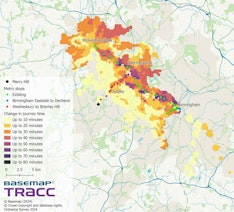
TRACC used to overturn decision to close NHS emergency centre
In the spring of 2014, Somerset CCG set out to discover how a proposed centralised stroke service, based at Taunton Hospital, would affect the population of Somerset as a whole
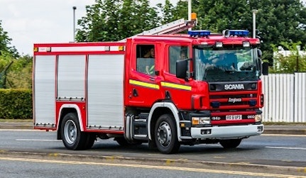
Saving Lives with Speed Data
Leicestershire Tri-Service Fire and Rescue are using Basemap’s speed datasets in their Command and Control System after initially trialing the data for 6 weeks.
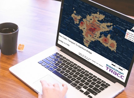
TRACC Used To Create Accessibility Indices In St Louis (USA)
East-West Gateway Council of Governments (EWG) serves as the Metropolitan Planning Organization (MPO) for St. Louis region which serves almost 3 million residents.
Get Started with Basemap
See how our digital mapping and transport data solutions can enhance your planning.
- 1 Book a demo – Get in contact to schedule a session at your convenience.
- 2 Meet our experts – Get a personalised one-on-one consultation with a specialist.
- 3 Find the right solution – Discover how Basemap can solve your specific transport challenges.

About Basemap
Government departments, city planners, transport operators, and consultants rely on Basemap’s products for accurate, repeatable, and evidence-backed transport analysis. In today’s smart cities, precise travel data is essential for informed decision-making.
Basemap’s cutting-edge transport software and data solutions empower government authorities, travel consultancies, emergency services, and transport planners with critical insights—improving mobility, enhancing efficiency, and even saving lives.
Recent News
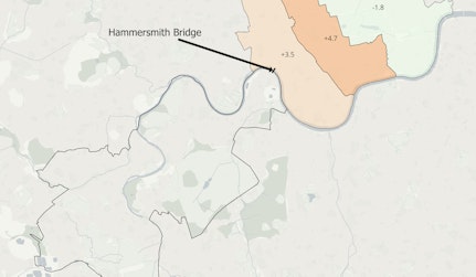
The Impact of Hammersmith Bridge Closure on Journey Times
The Impact of Hammersmith Bridge Closure: A Comprehensive Journey Time Analysis
Is London a 20 Minute City?
The concept of the 20 minute city is gaining momentum to meet both environmental and sustainable long-term demands. The initiative is designed to get residents living and accessing their places of need within a 20 minute journey, either through public transport, walking or cycling. The key aim is to reduce car dependency in cities for emission objectives.

Can Using The Proposed Superloop Give You Better Access to London Hospitals
Can Using The Proposed Superloop Give You Better Access to London Hospitals