Is London a 20 Minute City?
The concept of the 20 minute city is gaining momentum to meet both environmental and sustainable long-term demands. The initiative is designed to get residents living and accessing their places of need within a 20 minute journey, either through public transport, walking or cycling. The key aim is to reduce car dependency in cities for emission objectives.
About the Project
In this installment we look at access to supermarkets, hospitals and GPs, primary schools, secondary schools, and public transport stops in London..
All the cities begin with a foundation of a detailed road and footpath network, we used OS Highways which is available in DataCutter.
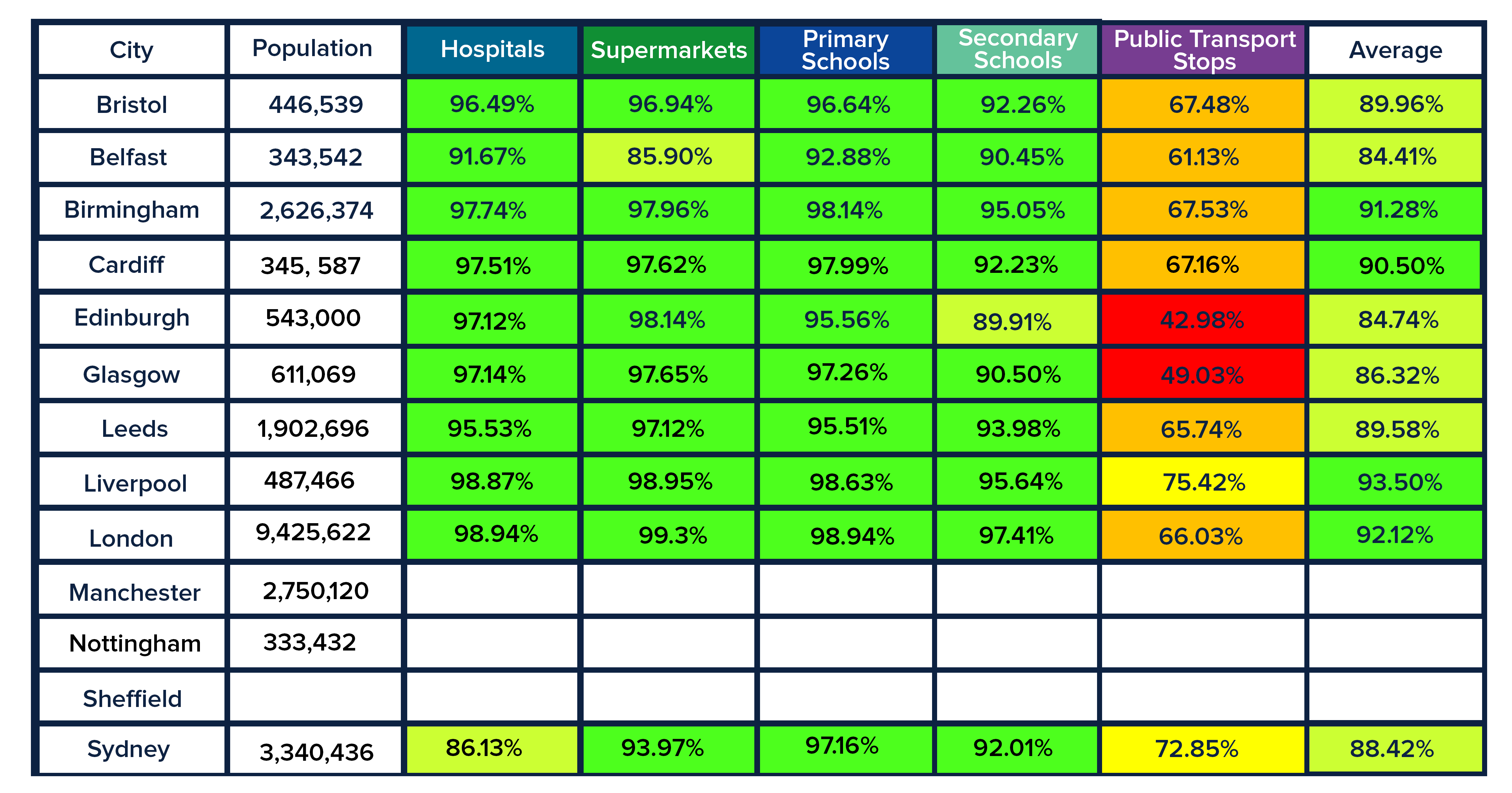
For the origins, Basemap created a grid of points based on the city boundary and then found the Points of Interest (POI) within this boundary for each destination type. This means that the accessibility to these destination points could reach beyond the city boundary but for the scope of this series, we are specifically looking at the accessibility within the city limits. So, the results of our TRACC analysis of London are in… With an accessibility percentage of 98.94%, there is little room for criticism in terms of how many residents and visitors can reach medical treatment in London.
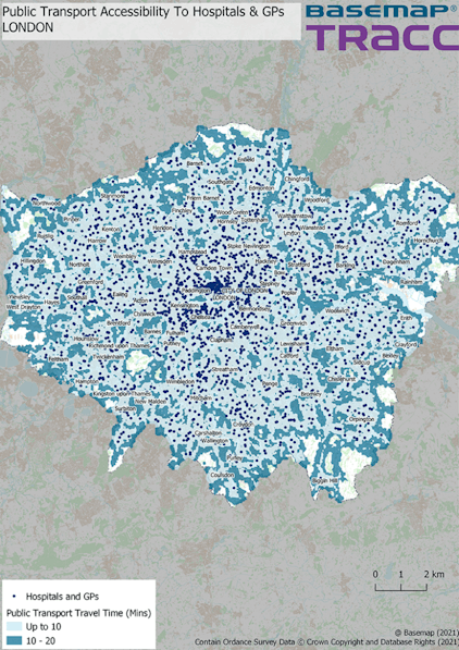
Public Transport Access to Hospitals and GPs
With an accessibility percentage of 98.94% there is little room for criticism in terms of how many residents and visitors can reach medical treatment with London.
The medical facilities that we have analysed numbered 3058 registered GPs, Hospitals, A&E and walk-in centres. This does not differentiate between private medical facilities and those that are run by the public healthcare system (NHS). It would be interesting in the future to analyse how many patients can access an NHS hospital within 20 minutes of public transport and/or walking. Food for… well… treatment for thought.
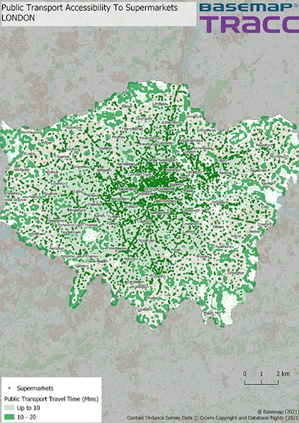
Public Transport Accessibility to Supermarkets
London’s 2021 population is now estimated at 9,425,622 (https://worldpopulationreview...., 2021) it is no surprise that the largest destination list in this analysis would be the supermarkets. Accessibility to Supermarkets came back at the very high percentage of 99.3% – possibly being the highest accessibility percentage we have or will have during this series of blog posts. The POI data loaded into TRACC 2.0 had the number of registered supermarkets, convenience stores, and local independent food stores numbering 9617. Access to Supermarkets and Hospitals are very similar in the visual representation of how many residents can access these facilities, next we’re going to see whether the education system is as accessible as medicine and food.
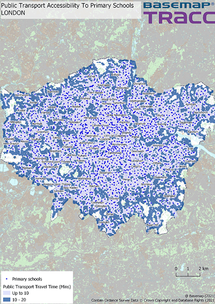
Public Transport Access to Primary Schools
Visually, there are some pockets of London where primary-aged students cannot access an education facility within 20 mins (but this is not too dissimilar from those areas with supermarkets and hospitals). Of the 1808 primary schools that were analysed 98.94% of residents in areas with dwellings in London can access a primary education facility within 20 minutes.

Public Transport Access to Secondary Schools
The structure of the contour is very similar to that of the primary schools for the results of Secondary schools, with larger pockets of more than 20 mins in north and south London but the overall accessibility score is still an impressive 97.41%. This percentage leads to an admirable visual output of how many secondary-aged students can access educational facilities in 20 minutes, despite having the lowest number of institutions (1005).
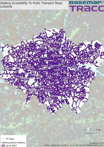
Access to Public Transport Stops London
And, finally, we shall have a look at how we measure the accessibility of all our destinations via the PT stop and their accessibility with 400m. Public transport options in London are numbered at 25816. Whilst the majority can access a PT stop within 400m, the actual percentage is only 66.03%.
In summary, London can be considered a 20 minute city if the majority of its residents (over 90% average) can access the key services listed above within the allotted time. Interestingly, the city’s access to public transport stops in total is less than cities such as Liverpool, Nottingham and Sheffield in other parts of the UK.
Recent investment in adding new tube stops, bus stops and new lines altogether (Crossrail) can support more residents to get more frequent access to their places of need.
