
Ottawa City Uses TRACC to Assess Benefits of Service Changes
| Client | Ottawa City |
| Date | 06.07.2026 |

Assessing Routes and Service Changes
OC Transpo, the municipal transit provider in Ottawa, Canada, is starting to use TRACC to assist with route and level of service planning. It is used by the Operational Planning team, responsible for Network Design, Service Reliability, and Scheduling. TRACC will be used to complement, and validate, existing methods for assessing the customer journey time, impact of transit network changes, and to identify gaps in existing network coverage when planning service to new development and growth areas.
Matthew Wolstenholme, Program Manager of Operational Planning, has previously used both Accession and ArcGIS to look at localised changes to transit services, but found that these did not provide the necessary schedule interrogation tools that his team needed. Since starting to use TRACC, the Network Design team have found it easier to test multiple scenarios as calculations can be done very quickly. Matthew noted that this allows them to do more iterative assessments, as it is quick and easy to make tweaks and re-run calculations multiple times. “TRACC has the potential to save us significant staff time on GIS analyses that can be utilised on other projects, and we look forward to using the software on day to day projects” said Matthew.
Further Analysis
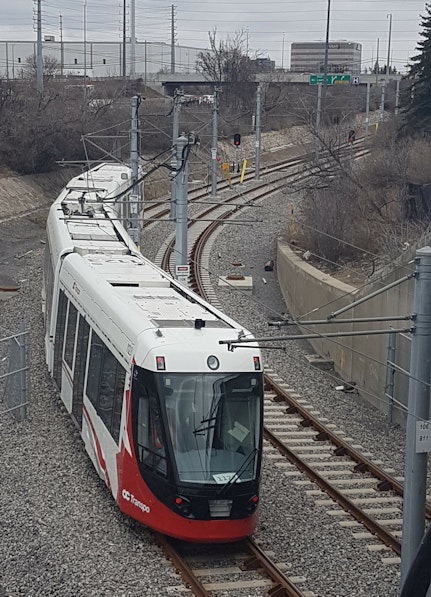
The City of Ottawa will shortly open O-Train Line 1, the Confederation Line. The $2.1 billion project, and the biggest infrastructure undertaking in the city since the building of the Rideau Canal, replaces part of the existing, proven, BRT based, Transitway system. Line 1 introduces a new operating concept whereby BRT will feed the crosstown light rail system at major transfer stations along the line. TRACC has proved beneficial to the team as they plan the City’s expanded multimodal transit network with the opening of Line 1. TRACC has allowed them to quickly assess the journey time impacts of route changes that are taking place to provide better connections with the new Line 1, to/from urban and suburban neighborhoods, and major places of employment.

Results
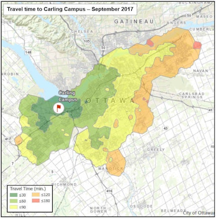
These maps show network wide journey time to the Carling Campus, before and after the opening of the West Transitway Extension. The maps show that, following the opening of the extension, journey time improved for an additional 73,000 (network wide) transit customers – mainly in the east end of the City.
Matthew noted that one of the important ways that TRACC will be able to help in the future will be in the ability to respond quickly to the frequent enquiries from elected members and customers, with regards to route, level of service, or bus stop amendments. Using TRACC, the team will be able to test and assess the benefits of changes quickly and with robust results. “Without TRACC, this essential transit journey time analysis will take much longer and tie up staff time that cannot be used elsewhere”.
TRACC allows us to quickly assess the benefits of route and level of service changes.

Matthew Wolstenholme
Program Manager, OC Transpo

Easier to test multiple scenarios as calculations can be done very quickly.
