
The Top Ways Mapping Data Can Be Used To Justify Location Provision

The Top Ways Mapping Data Can Be Used To Justify Location Provision
Public transport is in the midst of unprecedented change. Transport authorities, councils, and operators must adapt to grow patronage and ensure their operations are robust to meet changes in demand and manage congestion.
For transport planners, consultants and managers – travel time analysis play a major role. If part of your remit is to identify the right locations to implement new housing, retail, office, train link or a station used by people – then analysing that in your business case is crucial. Gaining insights by using Basemap’s travel time analysis tool can help bring important decisions in order to justify development.
Here’s how some of our top clients have used it.

1. Comparing accessibility by different transport modes
Adding multi-modal travel data can offer additional insights when running an accessibility study. This allows you to create catchment areas through the visual aid of contours showing all of the reachable locations within a time limit from multiple points of origin, using any mode of transport.
As an example, the visualisation below illustrates the differences between driving and public transport catchment areas. The results paint a true reflection of how reliant we are on car use in England to access key services. This data produced by TRACC helps policy decisions to be made as well as proposals for services to be prioritised.
The areas in red show the public transport times on average between 0 and 45 minutes, whilst the blue key represents cycling and amber car. The 2015 and 2017 results showed how journey times have remained higher for public transport in comparison to both walking and cycling.
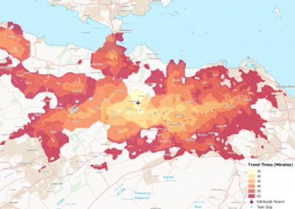
2. Performing a public transport network analysis
Running a public transport network analysis can be particularly helpful for justifying a build/re-build or revamp. For example, creating public transport catchment areas can identify public transport blank spots that require improvements to public transport or footpaths. In Edinburgh, the Council wanted to improve access to the airport for residents. By creating a new tram link from East and West of the city, the work used by TRACC software helped improve access for over 6,000 residents to access the Edinburgh hub within 30 minutes, whilst over 20,000 more could reach within an hour.

3. How to calculate road speed data
To determine the average speed on any road and to optimise routes during the different day/time period, our clients have used detailed data from GPS inside vehicles, this speed data can be integrated with the Highways Analyst tool or can be purchased in the pre-defined periods: Peak AM, Peak PM, Off Peak, Evening, Night Time and Weekend.
Basemap separates these products into two, Highways Analyst and Trafficmaster Speeds.
For Mersey Travel, historically they had to manually add road links and GPS speed data individually allowing for errors and many weeks to complete a task that can be done in a few hours with Highways Analyst. The cloud-based solution meant they could remotely export road data in bulk, making their full network visible to effectively plan any future junction developments and plan for bus operations into the city.

4. Planning for future transport network developments
Travel time insights can help to better understand the impact of future transport network changes.
The proposed extension of Crossrail is looking to improve access to London’s main airport hub, Heathrow. By using TRACC, it’s possible to analyse what impact the extension may have on the surrounding areas.
For example, the visualisation below shows how many more people can access all terminals, broken down by 30, 60, 90 and 120 minute intervals. The interesting take-away is how many more it benefits Heathrow – due to the excellent Crossrail links from the capital centre. Unfortunately, other airport hubs like Gatwick have no improvement, though a new high speed link could be modelled between the two hubs to show how this might improve airport hub access.
What kind of projects can TRACC be used for?
Assessing a New Development
- Active Travel
- Office Relocation
- Adjusting Public Transportation
- Car Park Assessments
- Local Plan Creation
- Creating an accessibility score