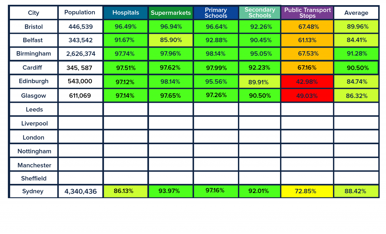
Is Sydney a 20 Minute City
Last week we promised you an additional international piece surrounding the 20-minute cities pursuit, and we didn’t disappoint!
We’re taking a gander at cities beyond the pond to find out whether places outside our island follow the 20-minute model. But truth be told, I think we got a little fed up with the UK after being confined to it for so long and wanted a change of scenery.
For our first international stop, a virtual boat trip to Austalia’s Emerald City, Sydney.
We create 5 accessibility maps based in the UK. To supermarkets, hospitals and GPs, primary schools, secondary schools, and public transport stops. We’ve added a little twist by taking a quick peek at some international cities as well to see how these fare in comparison.
The data used for cities outside of the UK will be a little different although the structure of the maps remains the same. International cities will also begin with a foundation of a road network, predominantly taken from OpenStreetMap. On top of this, Basemap layered the public transport network, using the latest GTFS data from Transitland.
For the origins, Basemap created a grid of points based on the city boundary and then found the Points of Interest (POI) within this boundary for each destination type. This means that the accessibility to these destination points could reach beyond the city boundary but for the scope of this series we are specifically looking at the accessibility within the city limits. In an international setting, the Points of Interest are sourced from various places and will be referenced for each individual city.

Access to Hospitals & GPs
Starting with the 348 Hospitals and GP’s destination points, this already looks to be the least accessible of all the destinations, at only 86.13% for the city’s population. Not discrediting how good the overall access is for a city of its size but it’s clear there are some areas, external to those rural, where access is lacking likely because of where these facilities are based. There is a relatively even spread between the journey time ranges, but in the more Western areas more people need to travel between 10 and 20 minutes. Again, an increase with an even spread of Hospitals and GP’s would help with this.

Access to Supermarkets
While there is a higher number of supermarkets (545) and a slight increase in access (93.97%) compared to secondary schools, you can see areas that are inaccessible closely follow the same pattern. Even though there are more destinations, most are primarily located in the city center of Sydney making it harder for some residents, although few, to buy their shrimp for the barbie in 20 minutes.
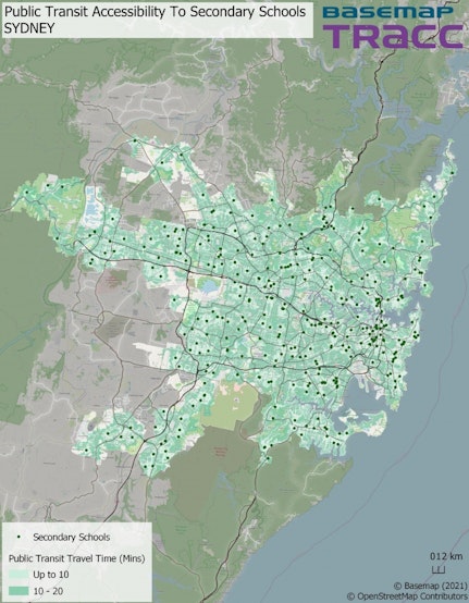
Access to Secondary Schools
While there is a higher number of supermarkets (545) and a slight increase in access (93.97%) compared to secondary schools, you can see areas that are inaccessible closely follow the same pattern. Even though there are more destinations, most are primarily located in the city centre of Sydney making it harder for some residents, although few, to buy their shrimp for the barbie in 20 minutes.

Access to Primary Schools
With the highest access (97.16%) out of all the destinations, there is really no Primary school that 0-15 year olds can’t access within 20-minutes, which isn’t surprising with the large number of these that are available (891). Better yet, is very few students need to travel more than 10-minutes. Any areas that require a 10-20 minute travel I put down to there being smaller clusters of schools. As expected, gaps with no accessibility are predominantly in rural areas of Sydney.

Access to Public Transport Stops by Walking
As Sydney is by far the largest city we’ve looked at to date, it comes to no surprise that it has the largest public transport network with 20,346 stops which can be accessed on foot within 400m.
Although access at 72.85% is one of our highest percentages yet, if you’re comparing to cities such as Bristol and Cardiff which are significantly smaller in size and roughly have 5% less access you may question as to whether access to public transport stops is as high as it could be considering the large number of them.
Similar comments made (when we looked at Glasgow) about large cities can be applied in the case of Sydney. By being that much bigger there is a necessity for a strong public transport network to ensure good accessibility. Sydney has proven itself to provide more than good enough access to its residents and in turn, can be called a 20-minute city.
It has also shown there is more to having a high density of destinations and that their location is just as important.