Is Sheffield a 20-minute City?
About the Project
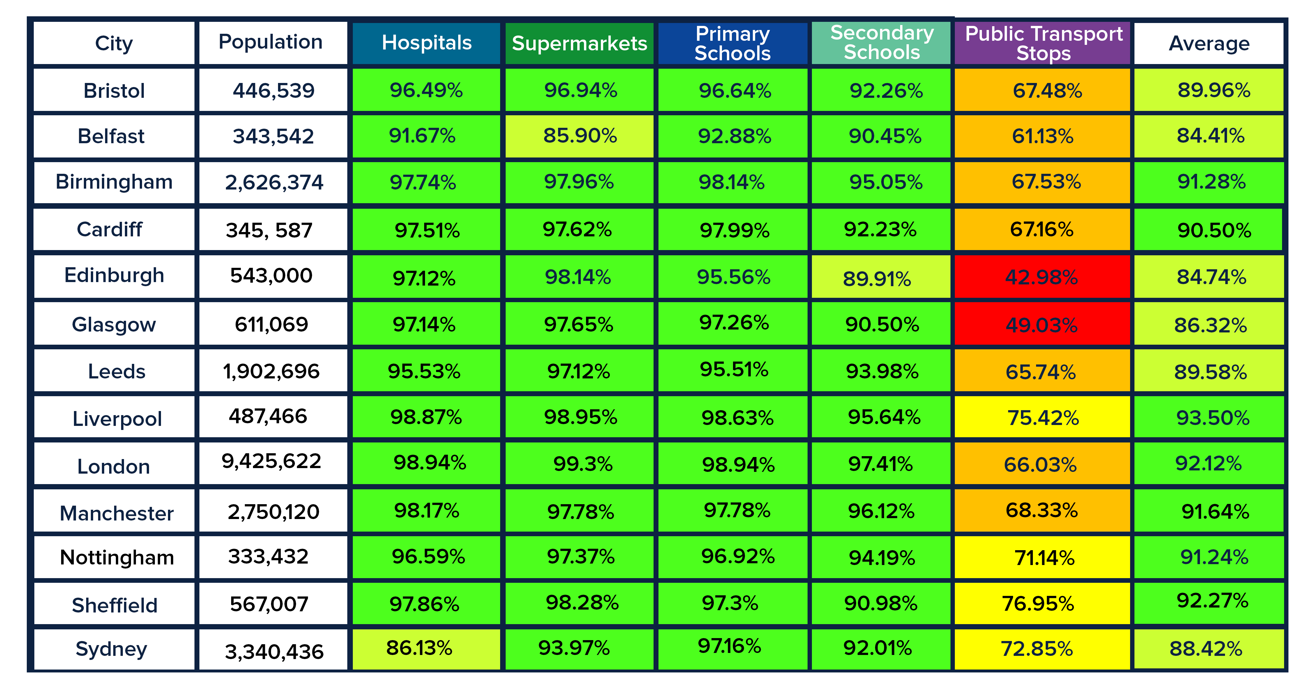
We are focusing on Sheffield and creating 5 accessibility maps. To supermarkets, hospitals and GPs, primary schools, secondary schools, and public transport stops.
All the cities begin with a foundation of a detailed road and footpath network, for cities in
Great Britain we used OS Highways; now available in Datacutter. On top of this, Basemap layered the public transport network, for consistency, public transport data will all be taken from Q4 2020, allowing for any drastic changes to happen in 2021 without skewing the comparison results.
For the origins, Basemap created a grid of points based on the city boundary and then found the Points of Interest (POI) within this boundary for each destination type. This means that the accessibility to these destination points could reach beyond the city boundary but for the scope of this series we are specifically looking at the accessibility within the city limits. Due to the different countries within this project, the Points of Interest was sourced from various places and will be referenced for each individual city.

Access to Hospitals & GP's
Another strong start for accessibility to Hospitals & GP’s (97.86%).
Looking at the area as a whole, rural and all, it may come as a surprise to see how good access to the 115 Hospitals & GP’s are. However, if you consider that all of the urban area inside, bar a small part in the East, the figures aren’t all that shocking. So, whilst visually it isn’t one of the best-looking cities in terms of access, the numbers tell a whole other story.

Access to Supermarkets
Likewise with residents’ access to Supermarkets, another great result at 98.28% placing it in the top 3 for this map.
Following a similar pattern to the map before but with better access to the West and fewer residents required to travel more than 10 minutes to the 573 Supermarkets open in Sheffield. The boost in these areas are probably because of the increase in shops available to its residents.

Access to Primary Schools
Yet again, a great result for Sheffield (97.3%), perhaps not the strongest out of all the cities, but pretty darn good, nonetheless.
Access to Primary Schools (132) compared to the first two maps, overall has some similarities but the reduction in access can mostly be seen in the North with also a bigger proportion of 5-10 year olds having to travel up to 20 minutes to get to school.

Access to Secondary Schools
A sad turn of events with this one. Quite a large reduction in accessibility from Primary Schools to Secondary Schools at 90.98%. Perhaps with a large drop in destination numbers (38), this is the impact it has had on the census results. Making it one of the poorest, if not the worst result for Secondary Schools this year. And to add salt to the wound, majority of Sheffield’s 11-16 year olds are expected to travel anywhere between 10 and 20 minutes and more without access primarily around the city’s boundary.
But…… we start as we mean to go on! In spite of the poor performance) of Secondary Schools (relative to the other Sheffield scores. Sheffield has managed to finish just as strongly as it had started, if not even better. With a result of 76.95% for access to public transport stops, this places Sheffield first place for this map, provided I have done my maths correctly. Considering that there are only 2694 stops in the city, which is by far not the highest we’ve had, it’s managed to provided the best access on foot for its people.

Access to Public Transport
Sheffield has defied the odds and made it onto the list! Considering that quite a large proportion of the city is rural, its accessibility is particularly high compared to some cities that looked far more urbanised than Sheffield. And to top it off, the city has outdone itself on access to public transport stops, exceeding others by a landslide. Whilst placement of destinations may have been a small factor in how its access was distributed, size and its make-up (rural vs. urban) seemed to have less of an impact unlike in other cases over the year. It goes to show you really shouldn’t judge a city by its contour.
As was mentioned at the start, this was our final step in our journey looking at which of the biggest cities in the UK meet the 20-minute city concept. But… this isn’t quite the end of it all, keep an eye out for another blog later this month where we will be recapping the last year’s voyage.