Is Nottingham a 20-minute city?
We are focusing on a different city and creating 5 accessibility maps. To supermarkets, hospitals and GPs, primary schools, secondary schools, and public transport stops.
All the cities begin with a foundation of a detailed road and footpath network, for cities in Great Britain we used OS Highways; now available in Datacutter. On top of this, Basemap layered the public transport network, for consistency, public transport data will all be taken from Q4 2020, allowing for any drastic changes to happen in 2021 without skewing the comparison results.
For the origins, Basemap created a grid of points based on the city boundary and then found the Points of Interest (POI) within this boundary for each destination type. This means that the accessibility to these destination points could reach beyond the city boundary but for the scope of this series we are specifically looking at the accessibility within the city limits. Due to the different countries within this project, the Points of Interest was sourced from various places and will be referenced for each individual city.
The results for Nottingham are in…
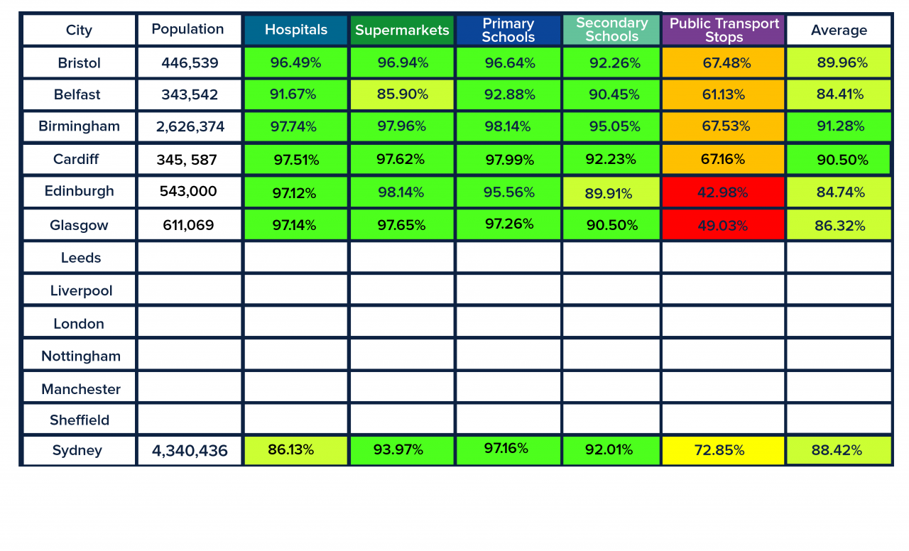
Access to Hospitals & GPs
At a glance, access seems very good, with only few areas, mostly in the southern part of the city that can’t reach any of the 56 Hospitals or GPs in 20 minutes. Despite this, it isn’t one of the best 20-minute cities with only 96.59% access. We’re not knocking that overall access is considerably high but out of the cities we’ve looked at so far it currently sits in the bottom three.
On the flip-side most residents only need to travel up to 10 minutes before reaching any Hospital or GP. With some that have to travel just that bit further (10-20mins), primarily because these areas are lacking in such facilities.
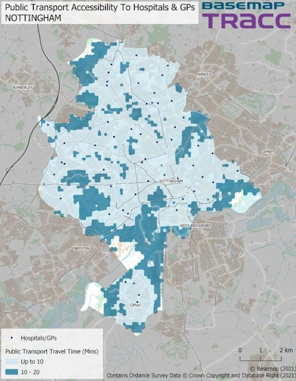
Access to Supermarkets
Access to supermarkets are just that bit higher at 97.37% with slight improvements to the up to 10-minute banding, making it easier for more people to travel in this time.
I would guess that having more destinations (372) is one reason behind the change in access. Whilst they’re not quite evenly spread, the location of the supermarkets where the hospitals map previously didn’t have any, clearly had an impact for the better.

Access to Primary Schools
Following a similar pattern as the first map but with a very small increase in access for 5-10 year olds (96.92%) and some variances between the two travel time ranges.
All 73 Primary Schools are accessible bar the few areas which has been highlighted already. Though by now it is clear that these are quite rural areas, which would explain the result.
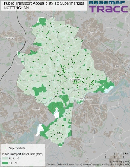
Access to Secondary Schools
Accessibility to Secondary Schools has experienced quite a large drop out of all the services (94.19%). Supposedly a drop in destinations points (32) looks to have had an affect on how many 11-16 year olds can get to school in 20-minutes. Whilst it’s been stated in the past that the number of destinations isn’t necessarily all that important, it’s becoming all the more clearer that the placement of destinations does play a key role. Particularly, with the change in distribution between the different travel time bandings.

Access to Public Transport Stops by Walking
Another low number of public transport stops with a surprisingly high access of 71.14%. Whilst 1294 stops is only a little higher than one of the first cities, Bristol, access has jumped up by almost 4%.
Quite surprised to see areas that had the best accessibility (under 10 minutes), that there are so few stops reachable in 400m.
Despite less impressive accessibility scores unlike October, London, which was at a new high, I think it’s safe to say Nottingham is still very much a 20-minute city with what we’ve seen. Especially with having one of the lowest number of public transport stops, it exceeds expectations with overall access being greater for residents that need to get to key services quickly compared to some cities with a larger transport network. Though it should be noted that its size might play a part in this! Either way, it doesn’t lessen its standing as a 20-minute city.