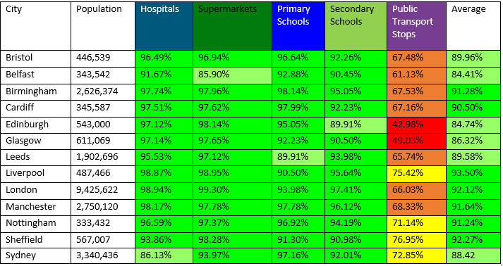
Is Liverpool a 20-minute city?
We look at different cities and create 5 accessibility maps. To supermarkets, hospitals and GPs, primary schools, secondary schools, and public transport stops.
All the cities begin with a foundation of a detailed road and footpath network, for cities in
Great Britain we used OS Highways; now available in Datacutter. On top of this, Basemap layered the public transport network, for consistency, public transport data will all be taken from Q4 2020, allowing for any drastic changes to happen in 2021 without skewing the comparison results.
For the origins, Basemap created a grid of points based on the city boundary and then found the Points of Interest (POI) within this boundary for each destination type. This means that the accessibility to these destination points could reach beyond the city boundary but for the scope of this series we are specifically looking at the accessibility within the city limits. Due to the different countries within this project, the Points of Interest was sourced from various places and will be referenced for each individual city.
Staying in the North we’ve taken a relatively quick drive down the M62 to do some boat watching down at the docks in Liverpool.

Public Transport Accessibility to Hospitals & GPs
And I think we can already tell that we have a new winner for city with the mostest. With accessibility to Hospitals and GP’s in Liverpool at an almighty high of 98.87%. That’s just over 1% more than what was seen in Birmingham and we thought that was a lot! With only 101 destinations, this certainly is incredible for its residents. And with majority only required to travel up to 10-minutes to get to a hospital or GP makes it all the better.Areas with no accessibility are a result of there being no destination points, likely because geographically it would be difficult to place such establishments there. Though with census results as high as this, more really aren’t necessary.
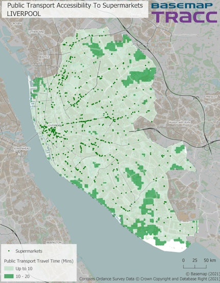
Public Transport Accessibility to Supermarkets
Another one that has exceeded expectations. Although there are lots more points for Supermarkets (644), it doesn’t diminish the impressive 98.95% of access that it has to offer in Liverpool.
Again, we are seeing a similar trend here as we did for Hospitals & GPs, whereby most residents only need to travel up to 10 minutes for their weekly shop. Though there look to be fewer pockets of 10-20mins suggesting that perhaps even more people don’t have to travel as long.
There is also slightly more coverage near the docks at the top of the city, perhaps because of the abundance of supermarkets that are located nearby.

Public Transport Accessibility to Primary Schools
Another map closely following suit to the previous two with accessibility for 5-10 year olds at 98.63%. Although slightly lower, this is still very good. Whilst the number of primary schools is a little higher (119) than hospitals, it is unexpected to see a slight drop in access. That’s not to say that having more destinations will always amount to better accessibility, as previous cities have quite rightly shown us. It’s difficult to say why this might have occurred but the larger areas for 10-20mins in the south of the city and additional pockets of inaccessibility could well be the reason for it.

Public Transport Accessibility to Secondary Schools
The lowest access (95.64%) so far is to Secondary Schools. Same areas that already expected residents to travel between 10 and 20 minutes, has grown quite significantly for 11-16 year olds. With also less accessibility in the southern part of the city than there was already. Again, the likely cause of this being the low number of destinations (46) and so few of them placed in this part.
Quite obvious as to who enjoys going to school more!
Joking aside, despite this being the lowest out of all Liverpool’s services, it is far from being the worst if you’re comparing it to other cities, with yet again the highest result for Secondary Schools.

Walking Accessibility to Public Transport Stops
Similarly, whilst the access to 1615 public transport stops looks to be extremely low (75.42%), it is in fact the highest by almost 7% (if we’re only comparing against UK cities).
1615 public transport stops is a lot less than many of the other cities we looked at that were deemed far less accessible percentage-wise. But that begs the question; can we really compare cities that are not only separate in size but also have a different geographic make-up (more rural).
We can without a doubt call Liverpool a 20-minute city. It has shown to be the most accessible city to date with some astounding results. Surpassing one of our earlier city’s, Birmingham by a small landslide. Considering its size and the fewer number of key services in the area, it certainly is impressive but is its size what makes it so easily more accessible in 20 minutes?