


The development proposes a significant increase in housing and associated infrastructure within the rural district of Waverley. UK Government has suggested a need for 1,481 new homes per year in Waverley, this is two and a half times the requirement in their Local Plan and would result in the Borough’s population increasing by around 50% over the next 20 years according to Councillor Liz Townsend as outlined here. This means that there is a lot of pressure to build new homes whilst ensuring that future residents have equitable and sustainable access to key services which is vital to aligning the development with the National Planning Policy Framework (NPPF).
Dunsfold Park, the home of the Top Gear test track, has been earmarked to help relieve some of the pressure despite plans to develop the site previously being muted for over 20 years. The current plan is for 1800 homes as well as key destinations such as a GP, primary school and local shops. The development intends to encourage travel by sustainable modes as well as reducing the need for residents to travel for their day-to-day needs. The goals of the development line up with those of the NPPF, which was published in December 2024 with the aim of ensuring that locally prepared plans are carried out in a sustainable manner; economically, socially and environmentally.
We analysed how well the current plans for Dunsfold Park meet this guidance with the help of TRACC, where we used the latest road and transport networks as well as implementing the proposed changes to analyse the connectivity of the development site.

The NPPF focuses on sustainability as a whole, in terms of environmental, social and economic sustainability. This involves working to reduce climate change impacts through features such as tree lined streets to provide shade, sustainable-urban-drainage (SUDs) to reduce the chance of flooding and houses designed to reduce energy consumption by implementing solar panels and insulation. Dunsfold Park will include extensive new planting as well as retaining and reinstating historic hedgerows. The development will include a new pond as well as many swales and areas for temporary stormwater storage. The houses within the development will have high levels of insulation and use local materials to reduce emissions from transport and reflect the local identity.

The focus on green spaces also helps to meet NPPF guidance on improving health and wellbeing, with these promoting active travel and better air quality. As well as these open spaces, the development includes plans for sports and leisure facilities to encourage more active lifestyles for those living in the area. The village centre will include shops and services intended to meet the day-to-day needs of the residents to reduce the need for car journeys and further reduce carbon emissions whilst promoting active travel.

The NPPF states that developments should provide a real choice of transport mode to jobs, educations, services and open spaces. The addition of day-to-day services such as shops, primary school and a GP within the development means that journeys to these can be made by walking or cycling. However, with Dunsfold Park located in a rural area, many journeys are likely to be over longer distances and become more suited to car and public transport modes.
Due to this, it is important that the public transport options for the site are of high quality and provide services to key destinations. The current public transport in the area consists of bus service 42 which has 7 services per day on weekdays and four services on a Saturday connecting to Cranleigh, Dunsfold, Hascombe, Winkworth, Godalming, Farncombe and Guildford. This service provides Dunsfold Park residents with an option to get into Guildford for 7:40 or 8:44 with a return journey from Guildford at 17:15 which may meet some residents’ needs for travelling to work for a traditional 9-5. Although the low frequency of this service does not make it the most appealing option.
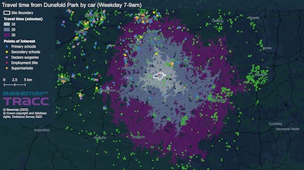
To evaluate how well the development meets the framework, we carried out the analysis within TRACC. We collected data including the Q3 2025 public transport network, Ordnance Survey multi-modal routing network and Ordnance Survey Points of Interest data using our Datacutter tool. This data was used to highlight the existing access to key services within Waverley. We then edited the data to investigate the proposed changes, for example the addition of roads and footpaths within the development, improved bus links and new services such as a primary school, GP and shops. These edits allowed us to analyse the impact of these changes on the development, as well as on the wider area.
We reviewed access to five key destination types, these included employment sites (based on MSOAs with >2500 employees), doctors surgeries, supermarkets, primary and secondary schools and open greenspaces. Using TRACC we analysed access to these destinations by car, cycling, walking and public transport. For public transport this was done for both the existing public transport network as well as an improved network, in which the 42 service diverted into the housing development and frequency was increased to hourly.

We identified that accessibility was much greater by car than by more sustainable modes. Walking showed particularly poor accessibility due to the rural nature of the site and its distance from the different destination types. This would be further impacted if only roads with 100% pavement presence were used as routable links due to the lack of pavements on many of the roads around the development.
The improvements to public transport allowed for additional destinations to be reached within 30 and 60 minutes as well as these journeys being available more regularly throughout the day and with a shorter walk to the bus stop. The existing 42 service has 7 services per weekday to the stops nearest Dunsfold park with the first service at 6:53 and the latest at 16:11. The amended 42 bus route travelled into the development allowing for shorter walks and had an hourly service.


It's also important to consider the impact of the development on the wider area. The addition of new services in this area will provide closer options for those in neighbouring towns and improvements to bus services and active travel links will improve access for the wider area. TRACC allows these impacts to also be analysed, providing the necessary data to support business cases and Section 106 agreements. For example, TRACC allows you to estimate the cost and number of vehicles required for a bus route and how these might change if stops are added or the frequency is changed. For this particular analysis, the 42 service was improved to an hourly service between 7am and 7pm, Monday-Sunday. This change led to an increased operating cost from £13,000 per week to £41,000 per week based on a cost of £5 per km. The existing 42 service is estimated to require a maximum of three buses, whilst the amended service is estimated to require only two due to the regular spacing of trips.


The current Dunsfold Park Plan includes elements which work towards the goals set out in the National Planning Policy Framework and will provide residents with options to live sustainably. However, due to the rural nature of the site location, it is important that the public transport links are carefully considered and are of a high enough quality that they provide a real alternative to the car for longer journeys.
TRACC gives local authorities the tools they need to talk to developers from a more informed and data driven point of view and gives developers the tools they need to ensure that the plans they make are as sustainable as possible and that transport is not an afterthought.