
Can a New Train Station in Merseyside Increase Travel Time Accessibility?
Rail users and residents will benefit from a new station opening at Headbolt Lane in Kirkby, Merseyside in the next few months.
The station’s location is just north of Kirkby and will be connected to the Northern Mersey Railway network aiming to boost transport connections to Northwood and Tower Hill areas locally.
The proposal includes the new station to act as the terminus for Merseyrail’s Liverpool Central to Kirkby and to be included in the Kirkby to Wigan and Manchester services.
A big boost will be the added connections to and from Wigan and Manchester, offering further access to and from the smaller towns in Merseyside.
Can we see the improvements to the areas on a map?
We used TRACC to visualize the improvements by importing POI data, transport data and auto-generating a timetable based on Headbolt Lane incorporating a service on a Tuesday between 7-9am.

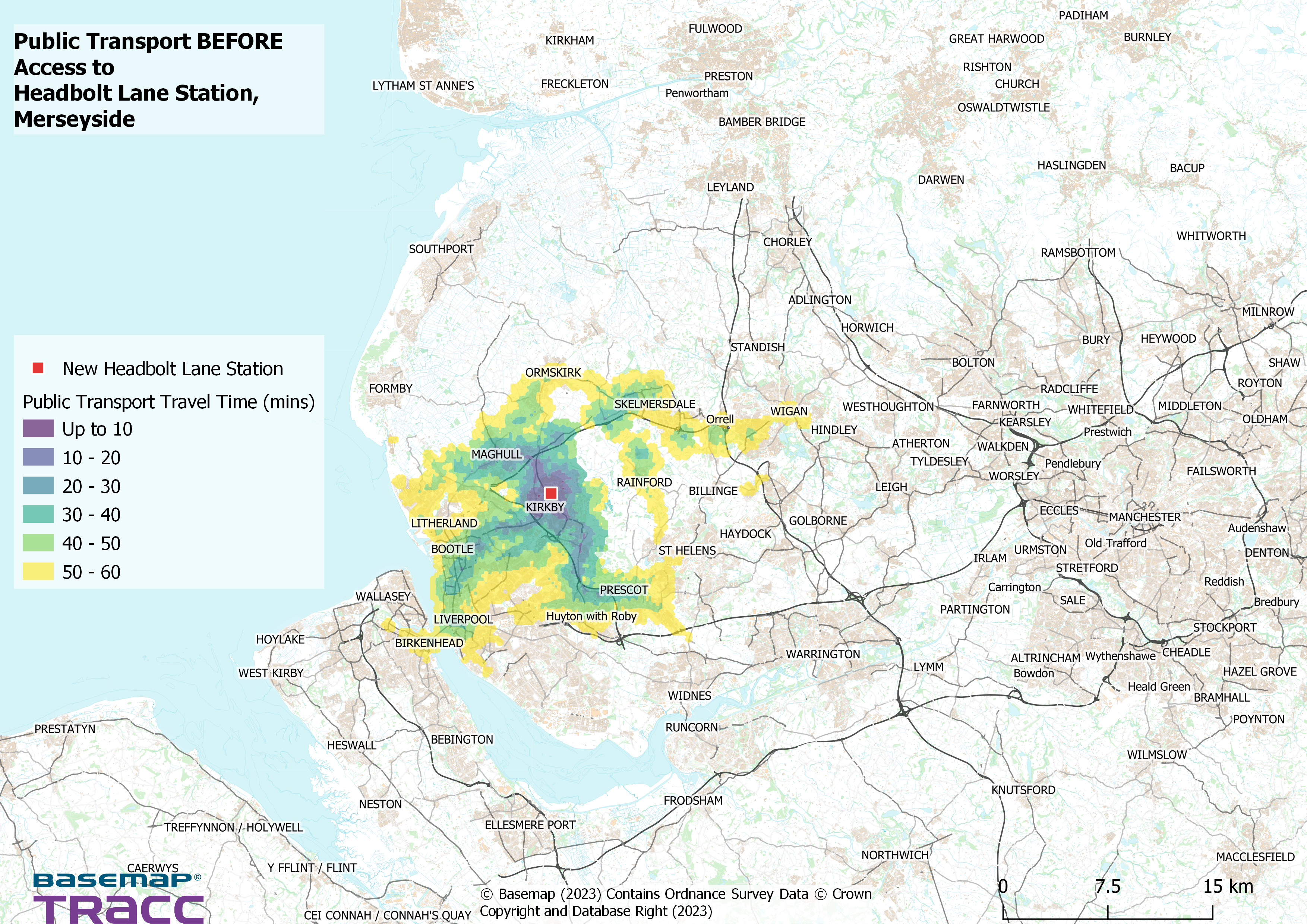
Current Access
We marked Headbolt Lane as the destination point for accessibility. The results shows a large portion of towns in Merseyside and Greater Manchester can take up to an hour to reach Headbolt Lane through all modes of transport. There is a confined area within 30 minutes that spans roughly 10 kilometres near the destination. What does access look like after the station has rail services?

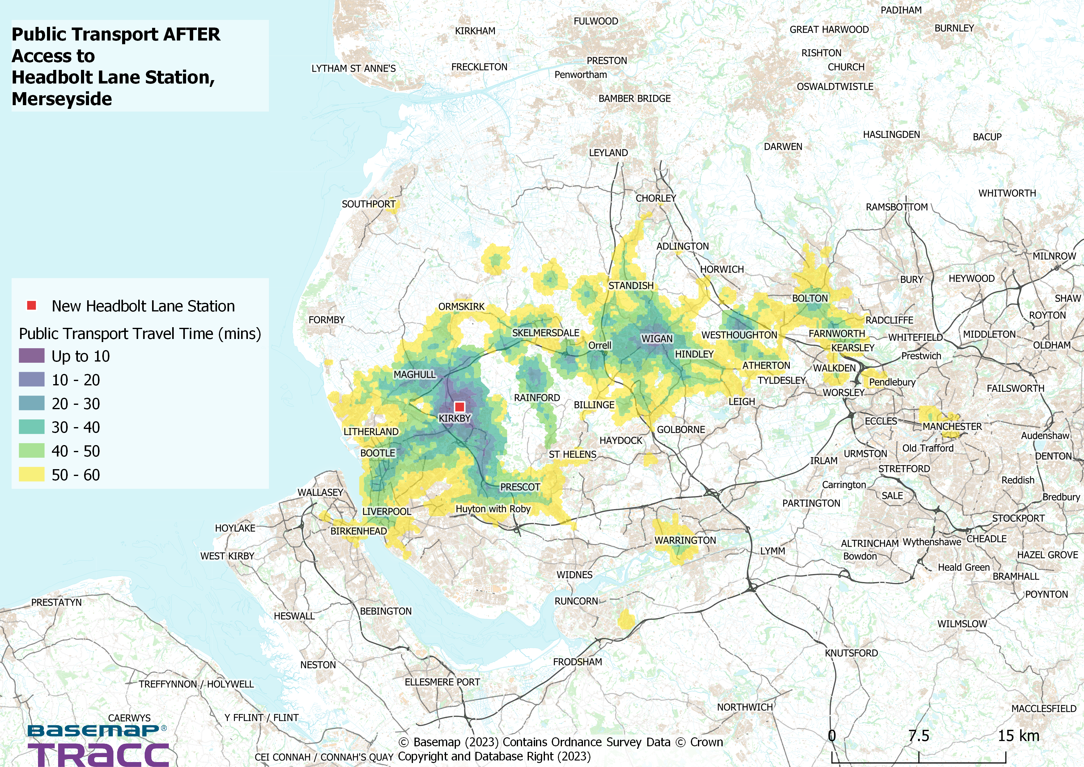
After Access
The picture is far greater when we applied Headbolt Lane as having several stopping trains in both directions from Kirkby to Wigan, Manchester and Liverpool stations. Several towns including Warrington, Bolton and Atherton can reach Headbolt Lane within an hour, giving residents and businesses more choice for speedier travel.
The Analysis
The method used to create these maps included; firstly, drawing a custom shape to the area of Mersey, Greater Manchester and North Wales. The second part was to download the Public Transport Network and Road Network of these areas. Finally, using TRACC we created a mockup timetable using information provided by Northern Railway. This project only looked at the access on a Tuesday, between 7am-9am.
What is TRACC?
TRACC is a multi-modal travel time analysis tool used to analyse different modes to measure access and mobility. Travel times are generated for walking, cycling, public transit and cars. These can be visualized in precise contours, thematic maps and detailed reports which can be enhanced using demographic data to give an accurate view on accessibility. Data can then be edited to create what if scenarios, such as introduction of a new bus lane, route or service, removal of a service or creation of new footpaths and cycleways. TRACC can also allow new locations to be analysed such as hospitals or housing developments.
This Project
For this project we analysed access to the new station of Headbolt Lane in Kirkby, Merseyside on a normal Tuesday morning between 7am to 9am. We measured access using the current context to this location (before any launch of the new station) and then afterwards by adding a mockup of the rail schedule incorporating Headbolt Lane with the Northern Mersey routes.