
Can a New Airport Rail Station in Scotland Offer Better Transport Access?
The £14m project was funded by Network Rail Scotland that includes two platforms, consisting of a passenger footbridge, bicycle station and electric charging points.
The Airport project is a significant milestone in a larger project that saw the completion of Kintore Station (which also happens to be on the Aberdeen-Inverness Rail Line) opened in November 2020.

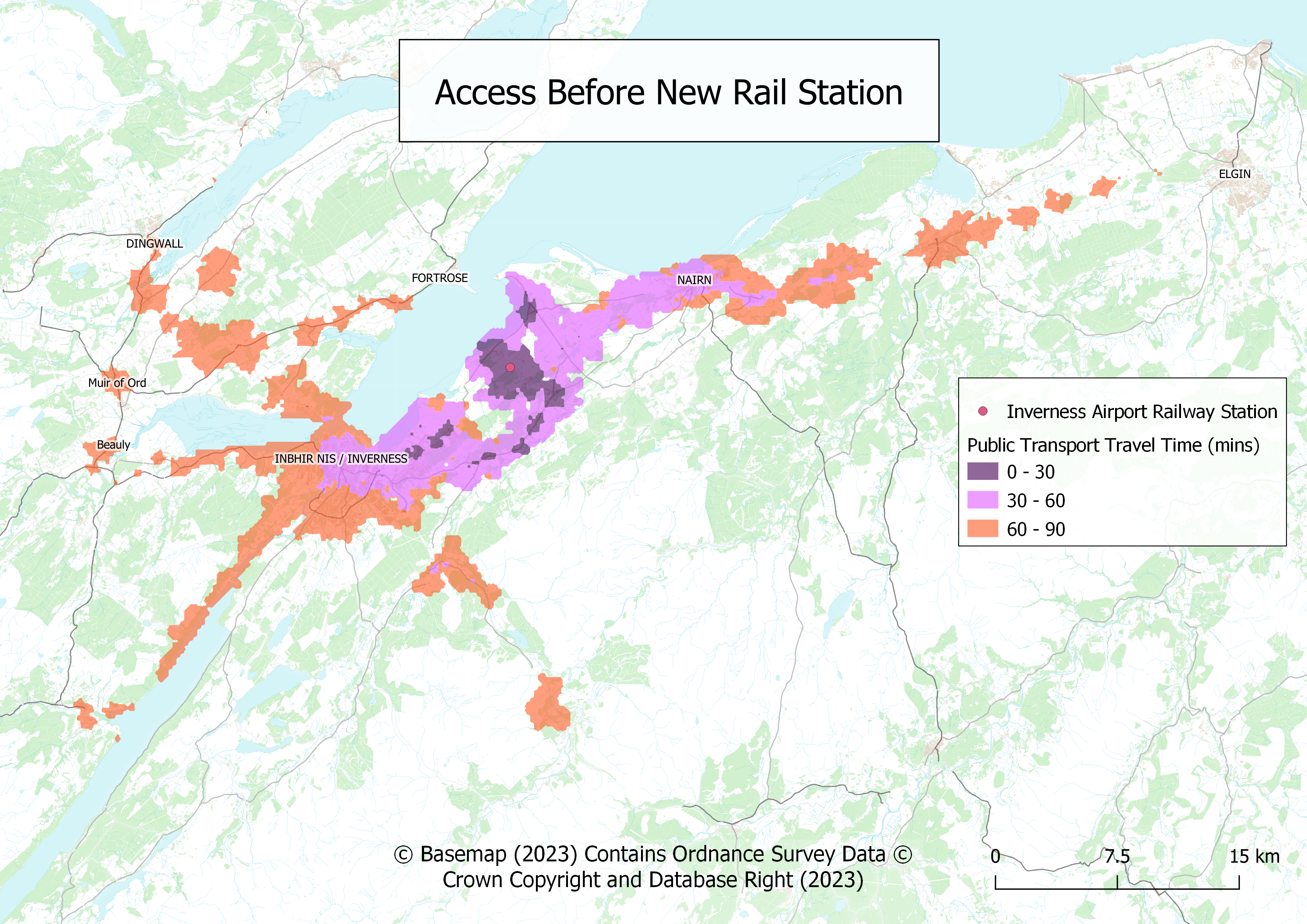
Before The Airport Rail Station Launched
A noteworthy takeaway from researching the station, is the existing bus service that will be incorporating the new station into the route, taking only 4 mins from airport station to the terminal building. Alternatively, airport passengers can opt to walk the 800 metres route from the rail station exit to the terminal building via a tarmac path.
We analysed the new station by using the rail station's location as the destination and visualising the public transport accessibility to that point. Does the access level increase?

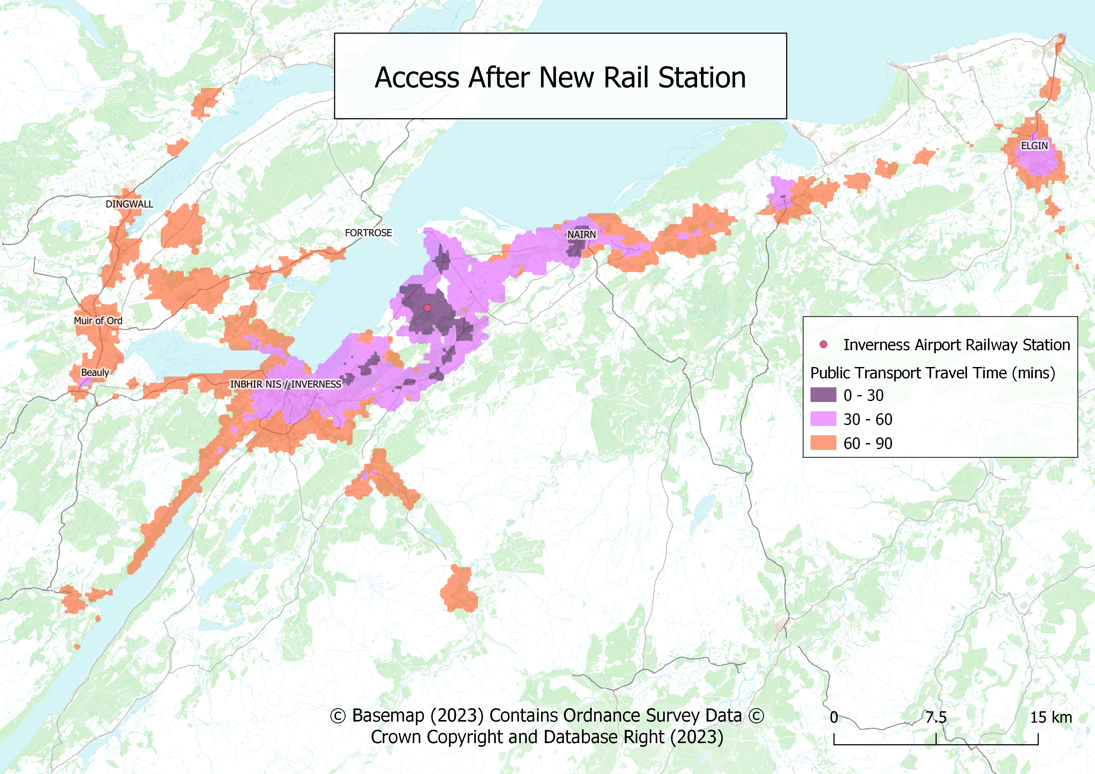
After The Airport Rail Station Launched
Using TRACC to add the new station into the timetable, we noticed trains run once per hour in both directions starting from 7:30am with the last being at midnight. We wanted to assess the time bands between 11.00am to 2.00pm due to most of the airport flight departures taking place around this time and into the late afternoon. We decided to create two maps, one showing the accessibility before the new rail station was introduced, and then a second map showing the visual access after the new rail station is introduced.
It is clear, access does improve within 1 hour and 30 minutes of travel to the rail station from both Western and Eastern directions. The station is located on the Inverness to Aberdeen line and clearly, the towns of Nairn and Elgin have quicker connections to the Airport Station. Northwest of Inverness, notably in the smaller villages of Beauly, Dingwall, and Fortrose can also boast to having connections under two hours to the Airport Rail Station.
As part of the Scottish Government's initiative to improve rail networks and infrastructure to cater for additional capacity, there are clear commitments to offering quicker public transport access for nearby communities, especially the towns located between the Aberdeen and Inverness train route.
Before Access to Inverness Airport Rail Station (using Public Transport)
Before Access to Inverness Airport Rail Station (using Public Transport)
What is TRACC?
TRACC is a multi-modal travel time analysis tool used to analyse different modes to measure access and mobility. Travel times are generated for walking, cycling, public transit and cars. These can be visualized in precise contours, thematic maps and detailed reports which can be enhanced using demographic data to give an accurate view of accessibility. Data can then be edited to create what-if scenarios, such as the introduction of a new bus lane, route or service, the removal of service or the creation of new footpaths and cycleways. TRACC can also allow new locations to be analysed such as hospitals or housing developments.
This Project
For this project, we analysed access to the new station of Inverness Airport Station in Inverness, Scotland on a normal Wednesday, between the hours of 11.00am – 2.00pm. We monitored access before February 2023, which was when the new rail station was added, and then looked at access after the station launch.