
Modelling Accessibility for Planning
| Client | Harrogate Borough Council |
| Date | 06.07.2026 |

Using TRACC To Support Local Plans
The planning team at Harrogate Borough Council use our TRACC software to help with assessment for every development site put forward by developers for consideration in the Local Plan. Prior to using TRACC, accessibility assessments were carried out manually calculating the distance between development sites and their nearest services which were taking a long time. Tom Horner, a Strategic Transport Planner at Harrogate who had used TRACC before suggested this work ‘could be done in one morning if using TRACC which would also provide a more standardised assessment system’.
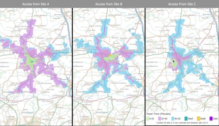
By using TRACC they can plug in 500+ sites, add all the destinations and run the calculations between the two ‘giving us an accurate figure that’s difficult to argue with’. This standard methodology allows them to confidently show developers how far they are from the nearest services and make decisions based on these accessibility indicators.
Further Analysis
Tom explained that the cost saving aspect of the TRACC software was the strongest argument when proposing a change in methodology to the council. “When we are talking about 500+ sites to assess and someone manually assessing the distance between each site and every different service, then on a time saving basis you can justify the cost of purchasing TRACC. Using TRACC was a bit of a no-brainer for us to be honest’.
He highlighted the importance of using standardised methodology to produce the accessibility reports as this is a vital part of the evidence base used for getting a local plan in place. ‘Politicians need to be sure that all the evidence has been collected properly and fairly, and we are able to confidently show that TRACC has allowed us to deliver this’.
Harrogate are now keen to use TRACC to help them with their emerging economic growth strategy by using the large-scale calculations and map outputs to show that business parks in the district offer fantastic locations for access to the North of England.
The latest version, TRACC Drivetime for OS Highways, adds many new features that have been optimised to work with Ordnance Survey’s premium dataset. Tom explained, ‘the fact that TRACC is continuously being improved and loading in the latest data, such as OS Highways, gives us the opportunity to use exciting new datasets and do other analysis that wasn’t previously possible’.
The standard methodology provided by TRACC allows us to demonstrate we have been fair to everyone. If the results are considered at examination I am confident to stand behind the TRACC outputs
Tom Horner
Strategic Transport Planner, Harrogate Borough Council

Accessibility Reports
Add context to contoured maps with fact-based evidence to support local plans

Large Scale Calculations
TRACC is supporting Harrogate Borough Council with large calculations and map outputs including emerging business parks

Continuous Improvement
TRACC is being tested and improved on a regular basis to support larger projects for businesses like Harrogate.